Tuesday, December 7, 2010

Chapter 18: Hawaii

The Location and Physical Setting of Big Sur reminds me of Hawaii...
Hawaii is in the middle of the Pacific Ocean , while Big Sur is on the Coast
Hawaii and Big Sur's locations are both relatively isolated
Hawaii's geology shows visible volcanoes and Big Sur's geology 
includes some of the most abrupt elevation changes on the entire Pacific Coastline.


McWay Falls at Pfeiffer Beach in Big Sur, CA reminds me of Hawaiian Paradise...


Big Sur Geology

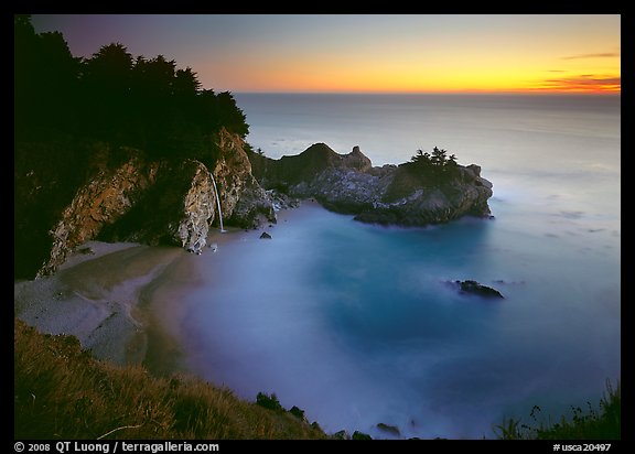
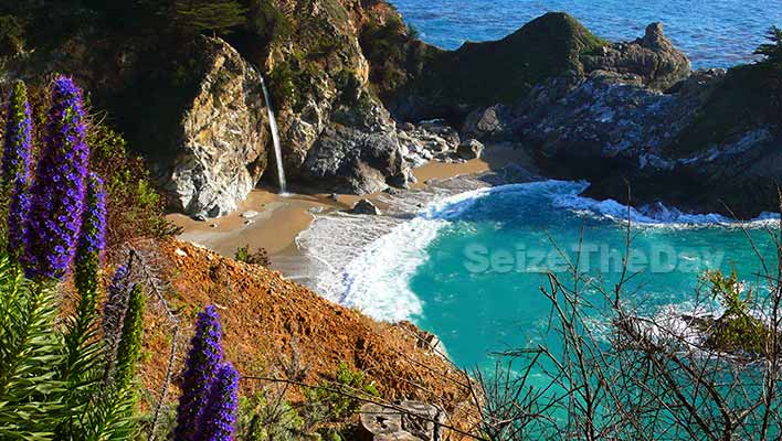
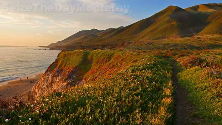
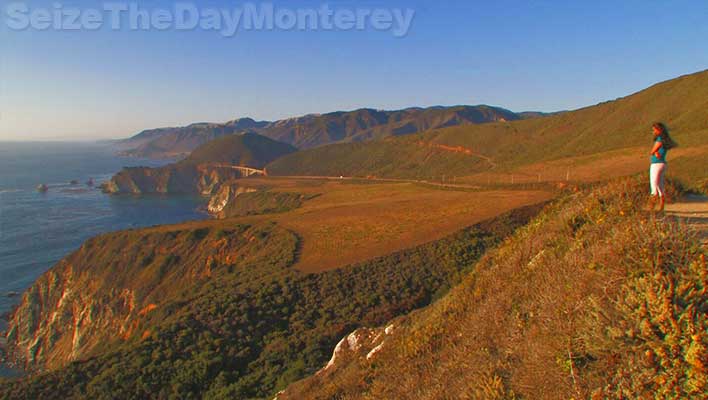
The mountains of the rugged Big Sur coastline rise to 5,000 foot summits within two miles of the ocean, the most abrupt elevation change of the entire Pacific shore.

Several hundred million years ago, river-borne sediments from a mountain range in what is now Mexico were deposited along the western coast. These layers of sandstone, siltstone and limestone were compressed and folded by the underriding of tectonic plates at the continent's edge. The sediments metamorphosed with pressure into schist, gneiss, granofels and marbles--now the oldest rocks in the Santa Lucia range.
By sixty five million years ago, this plate -- called the Salinan block -- began to drift northward. In response to the clockwise rotation of the Pacific Ocean's crust, the block was temporarily halted in its smooth progress and became jostled with faulting and uplifting, a process that still continues today. Seismic activity along the many faults is common as the mountains continue to be uplifed. Stream canyons frequently follow fault lines. Lateral faults are in the majority here, hence, most canyons parallel the coast rather than descend directly to it.
The highest peaks visible are granitic rock, which tends to be more resistant to erosion. In places where stream erosion was minor, the taller peaks may also be marble (metamorphosed limestone)--Pico Blanco is one such marble summit. The original sediments of sandstone and siltstone have been tilted up into cliffs in some areas. The sculpted shapes at Point Lobos are rare local examples of conglomerate formations.

Source: http://www.bigsur-coastline.com/geology.html

Pfeiffer Beach at Sunset...


Source: http://www.terragalleria.com/california/picture.usca20497.html


Morro Rock is one of a line of ancient volcanic intrusions or plugs sometimes called the Seven Sisters or The Nine Morros, depending on how many of the peaks are included in the count.


Morro Rock, Morro Bay CA near Big Sur


Source: http://patricksmithphotography.smugmug.com/Landscapes/California-Big-Sur-South/14079881_GcJrg


Evidence supports a theory that the morros erupted along old fault lines, leading to a hot spot deep within the earth. Morro Rock is dated to about 22 million years old. Black Hill, rising behind the Morro Bay Golf Course, and Hollister Peak are about 28 million years old during the Oligocene epoch of geologic history. The Morros may have formed south of the region with their remnants moving along the San Andreas fault to their current positions. 

Many other changes took place over the millions of years since Morro Rock solidified. About eighteen to twenty thousand years ago, the sea was 300 feet lower than it is today. Morro Rock stood on dry land. After the last glacial retreat, the sea rose again and Morro Rock was surrounded by salt water. A causeway to Morro Rock was made in 1933 through the Works Progress Administration. A causeway was created with materials blasted from the rock. 

The volcanic plugs tend to have steep sides of exposed rock, although buttresses slope from these peaks to make all of them accessible.  The Chorro Valley surrounds the Morros and features several hundred Chumash Indian mortar sites. If you would like to learn more about the history and geology of Morro Rock and other morros, visit the Morro Bay Museum of Natural History. 

Chapter 16: The North Pacific Coast

 According to the text, Regional Landscapes of the United States and Canada,  in "northern California and sourthern Oregon, the Klamath Mountains offer a jumbled topographyy that is a product of Pleistoscene glaciation and steam erosion. " (Birdsall pg 326) This is why the rugged coastline of the North Pacific Coast is very similar to Big Sur's coastline. Both have rocky coastlines with amazing natural landscapes, along with gorgeous mountains and cliffs over the ocean. However, both regions also get a lot of rain, though Oregon receives more on average compared to Big Sur. 

Big Sur storm total: 21.34 inches of rain at Mining Ridge

 BigSurKate reports 8.6 inches so far at her location in today's storm, 10 inches at Mining Ridge, which is 4.5 miles NW of Cone Peak.


Source: http://www.flickr.com/photos/selago/4009254455/

Landslides may result from too much rain along Coastal areas in Big Sur:


U.S. Geological Survey 
Scientific Investigations Map 2852 

Maps Sh Estimated Sediment Yield From Coastal Landslides and Active Slope Distribution Along the Big Sur Coast, Monterey and San Luis Obispo Counties, California

By Cheryl J. Hapke, Krystal R. Green, and Kate Dallas

2004

three maps of the coast showing erosion information


The 1982-83 and 1997-98 El NiƱos brought very high precipitation to California’s central coast; this precipitation resulted in raised groundwater levels, coastal flooding, and destabilized slopes throughout the region. Large landslides in the coastal mountains of Big Sur in Monterey and San Luis Obispo Counties blocked sections of California State Route 1, closing the road for months at a time. Large landslides such as these occur frequently in the winter months along the Big Sur coast due to the steep topography and weak bedrock. A large landslide in 1983 resulted in the closure of Highway 1 for over a year to repair the road and stabilize the slope. Resulting work from the 1983 landslide cost over $7 million and generated 30 million cubic yards of debris from landslide removal and excavations to re-establish the highway along the Big Sur coast.

Chapter 15: California

Big Sur offers some of the most spectacle views along the California Coast...

Things You Absolutely Have to do in Big Sur California!

Big Sur California, Mcway Falls is an absollute must do!
Are you looking forward to your Big Sur California trip? I bet you are and for good reason, there is lots to see, do, and experience. So you have your Big Sur Lodging squared away, you’ve checked out my driving tips, and now you’re looking for things to do.
Well, check out my must do list below for some ideas:

Things You Simply Must Do In Big Sur California:

Big Sur offers some of the best and most scenic hikes in California.

Hike the hikes that Big Sur California is known for, be it the easy or challenging ones! The goregeous view above is from the overlooking bluffs at Garrapata State Beach. This trail will lead you to a small canyon where the Doud Creek flows to the Pacific Ocean. Here is where you’ll find hundreds of blooming Calla Lillies depending on the time of year. Please don’t pick them, let others enjoy them too!


The Sea Otter is one of the most popular animals in all of Big Sur!

Witness Big Sur’s Magnificent Wildlife such as Sea Otters (above), Monarch Butterflies, Migrating Whales, Harbor Seals, Sea Lions, Great Blue Herons, and so much more! Find out the Best Spots to See Big Sur California Wildlife


Big Sur California Hurricane Point is a sight for sore eyes
Don’t miss the Best Big Sur California Sight Seeing Spots such as Bixby Bridge, China Cove Beach, McWay Falls, and Hurricane Point (pictured above) and so much more!


Glorious Sunsets in Big Sur are hard to beat
Watch a glorious Sunset from one of the Best Places in Big Sur to Watch the Sun go Down! See why McWay Falls (pictured above) and Pfeiffer Beach are two of the best places to watch sunsets!


China Cove at Point Lobos State Reserve in Big Sur is a "Cannot Miss"
Did You Know that Point Lobos State Reserve inspired the classic novel "Treasure Island"? You’ll realize why once you set foot on this amazingly beautiful park. It is hard to truly describe how magical Point Lobos is. Truly set aside at least 2-3 hours to check out one of my highest recommended things to do in Big Sur California and all of Monterey!


Big Sur California, Mcway Falls Waterfall pours onto a serene beach which washes away into the Pacific Ocean.
Take an easy five minute hike to experience the Crown Jewel of Big Sur California: McWay Falls at Julia Pfeiffer Burns State Park. If you could only stop and see one thing in all of Big Sur California, make sure it is McWay Falls!


Big Sur California, Seal Pupping at Point Lobos State Reserve
Are you visiting Big Sur California during March or April? Then you have to head down to the
Point Lobos State Reserve and see the Seals Pupping. You’ll get great views of the seals on the beach at Whalers Cove and China Cove Beach. Time will stand still while you’re watching the young pups play in the water with their mothers.


Big Sur California Sunset

Watch the Sunrise and/or Sunset from a Horseback Tour to the Beach! That’s right, you can take a horseback tour to the beach in Big Sur California. You’ll get to witness a glorious sunrise or sunset from horseback. And of course there are mid-day tours as well!


Source: http://big-sur-lodging.com/Big-Sur-California-Visitor-Guide/Pacific-Coast-Highway-Photo-Tour/pg-Big_Sur_CA_PCH-1_Vacation_Gallery/30-Sand_Dollar_Beach_California_Picnic_Day_Use.htm

California's Water Supply...


Source:http://taxdollars.ocregister.com/2009/02/23/water-survey/9578/


Big Sur is impacted with California's water supply shortage.  However, it is not affected the same same as Monterey Country. Unlike other portions of Monterey County, Big Sur already has the rural means of dealing water, sewage, and rain run off- which are not an issue for them. Instead Big Sur lacks the capacity and space regarding this issue.

California gets most of its water from Colorado...

Source: http://www.crwr.utexas.edu/gis/gishydro06/Introduction/TermProjects/Danner.htm


Source: http://article.wn.com/view/2010/12/03/Big_Sur_Land_Trust_buys_coveted_ranch_near_Carmel/


Water Discharge, cubic feet per second
Most recent instantaneous value: 40   12-07-2010  09:15 PST
Graph of  Discharge, cubic feet per second    
Create presentation-quality / stand-alone graph.   Subscribe to WaterAlert Introduction page WaterAlert      
Daily discharge statistics, in cfs, for Dec 7 based on 59 years of record more
Min
(1991)
25th
percen-
tile
MedianMost Recent
Instantaneous
Value Dec 7
75th
percen-
tile
MeanMax
(1967)
6.319294075981170

Gage height, feet
Most recent instantaneous value: 4.58   12-07-2010  09:15 PST
Graph of  Gage height, feet    
Create presentation-quality / stand-alone graph.   Subscribe to WaterAlert Introduction page WaterAlert
Source: http://waterdata.usgs.gov/usa/nwis/uv?11143000


Friday, November 12, 2010

Chapter 14: The Southwest Border Area: Tricultural Development

Ethnic Diversity: 
The Southwest Border Area is a culturally diverse environment with a blended history of American Indians, Hispanic Americans and Europeans. Big Sur is similar because it was also first inhabited by Native Americans and Spanish mariners. Some Today, Big Sur has a wide range of diversity within the culture. However, Big Sur is a small town with only about 1500 full time residents. Many touisits constantly come and go through the town adding to the currently diversity of the population. 


The Chumash Indians are the natives of the area we now call the Central Coast of California, stretching South of Malibu CA, North of Cambria CA, into Big Sur, out to the Channel Islands, and inland to the San Joaquin Valley. Their culture, homes, and territories were well established with over 150 independent villages, 7,000 square miles and a population estimated at over 18,000. Science dates the first settlements in this area back to 11,000 B.C.

Chumash means “bead maker”, “Seashell people” or “the ones who make shell bead money” and were hunters, gatherers and fishermen. Like many cultures they recognized the life of nature and how the lives of their people depended on its providence. Ceremonies were set based on the times and seasons of the moon, and sun. Their father, the sun, was celebrated in his respective seasons and 
transition points we call the summer and winter solstices.


Big Sur's Cooper Cabin
Cabin on the Sur
Kathleen E. Davis

State Historian II

The "pioneer cabin" at Andrew Molera State Park on the Big Sur coast, once part of the El Sur land grant, has long been an object of historical interest and romantic reflection. This three-room structure was built of hand-hewn redwood logs with lap-jointed and pegged corners, and roofed with hand-split redwood shingles. Its construction date has, until now, been a matter of speculation. Historical documents have indicated that a succession of structures was built on the rancho starting from its earliest days, and specifications for more than one of these appeared to correspond reasonably well with the existing cabin. However, thanks to modern scientific techniques, the cabin's construction date can be fixed with certainty, down to a two-month period in a long-ago springtime.
Image of Cooper cabin
The Cooper Cabin, in 1888, remains an attraction for history enthusiasts.
The El Sur grant was made in 1834 by Governor Jose Figueroa to Juan Bautista Alvardo. The grant was for two leagues of land, or roughly 8,880 acres. The expedient filed by Alvarado on May 14, 1834 stated that he had first petitioned for a provisional grant on August 12, 1830, and repeated his petition on February 26, 1831. It further asserted that he maintained "at this time . . . more than three hundred head of large cattle and nearly an (sic) hundred horses, all my own property, and have built a house and pens." [1]

Soon after the grant was made, the property was acquired by Captain J.B.R. Cooper, Alvarado's uncle by marriage. Although no official transfer was made until 1840, Cooper seems to have been directly involved in the management of the ranch as early as 1834, when he entered into an agreement with Job Dye for the latter to raise mules on the property.
Portrait of Captain J.B.R. Cooper, as he looked later in life. (Photo: Amelie Elkinston Collection)
This contract, dated June 16, 1834, referred to "his (Cooper's) farm called the Sur (about 30 miles from Monterey)," and arranged for Dye, a Kentuckian who had arrived in California in 1832, to breed mules from the mares and jackasses already on the place. It further called for Dye to construct "a well built log house with shingled roof, the body to be at least fifteen yards long and five and a half yards wide." Cooper was to provide the tools and "let the men that are in this employ on said farm assist . . . Dye in building (the) dwelling". He was also to pay Dye one hundred dollars for this work, with Dye to receive further recompense "should said men in said Cooper's employ not do their part in building said house."  [2]
Though there is no proof that the structure was built as specified, the duration of Dye's stay makes it likely that a dwelling was constructed. Furthermore, the dimensions of 15 yards by 4-1/2 yards match closely those of the pioneer cabin, which measures 45.66 feet long by 20.5 feet wide. If this were the cabin still in existence on the Big Sur River, it would clearly be the earliest log structure in all of California.

This structure seemed less likely to be the current cabin, but since adobe was cited only as a building material option, it could not be ruled out altogether. Yet another possibility was the structure specified in a third contract, made on February 23, 1861, between Cooper and George Austin, for a house to be built on the "Sud Ranch." Austin, a native of Massachusetts who came to California in 1847 as a midshipman on the Independence, had a long record of employment with Cooper. [4] He served as a chairman on the U.S. Surveyor General's 1860 survey of the rancho, and later was employed as caretaker of Cooper's Monterey dwelling. [5] At the time of Cooper's death in 1872, Austin wrote to Cooper's widow, Encarnacion, that he "had lost the best friend (he) ever had in the world." [6] Austin's occupation was variously listed as laborer, constable, and farmer, in the 1860 and 1970 Monterey censuses and an 1875 county directory, respectively. [2]
Austin's 1861 contract called for him to build a "block house" 46 feet long and 20 feet wide. It was to have three rooms, "the middle room to be one window to each room on the front and back of the house - and 2 doors - one at the front and one at the back of the middle room."[7] As noted above, the extant building measures 45.66 feet by 20.5 feet and has three rooms. The center room has interior dimensions of 19 by 19.5 feet; those on the ends measure 11 by 19 feet and 12 by 19 feet, respectively. The two side rooms have two windows each, one on the front and one on the rear, while the central room has a door on the front and a window on the rear.
Though no specific construction technique was indicated, the structure was clearly to be made of hewed logs and covered with shingles or clapboards. It is interesting to note that the use of lap jointed corners, also known as false corner-timbering, is common to the New England states, but is quite rare in the west. [8]
Image of 1897 map
Detail of an 1891 map identifying the structure as the "old barn," located just off-center. (Map: Cooper-Molera family papers)

The romance of the place has been in no way decreased by the revelation of its actual construction date. Retired forester Lester O. White, volunteering for the California Department of Parks and Recreation, took samples of five of the cabin's logs for tree-ring dating, using an increment borer and taking rubbings of exposed log ends. He then established a chronology of wet and dry weather cycles by taking samples from living redwoods in the area. With these data, he was able to establish that the logs were originally harvested in the spring of 1861, probably during the months of April and May, within two months of the signing of the contract between Captain Cooper and George Austin. There was no doubt as to this date, as consecutive drought years from 1857 to 1859 made the tree-ring sequence quite distinctive. Mr. White, who requires a rough time frame within which to work, had been told only that the cabin had been built sometime between 1825 and 1875.

Though the cabin is not the earliest log structure in the state, it is still clearly the earliest surviving structure on the south coast. Preservation efforts will be enhanced by the knowledge of exactly when and by whom it was built.

Friday, November 5, 2010

Chapter 13: The Empty Interior

The Mountains


The Empty Interior and Big Sur are slightly similar in that they are known for their "stark contrasts of aridity and lushness, which intermingle with wide desert valleys and rugged high mountains." (Regional Landscapes of the U.S. and Canada pg 252) The steep mountains of Big Sur are incredibly gorgeous yet very difficult to hike due to the varied terrain. Climatic conditions, both historical and current have contributed to the rugged yet nature of Big Sur. Arid, desert like canyons, jagged mountain peaks, and small canyons are part of Big Sur's mountain range. 


Source: http://www.google.com/imgres?imgurl=http://www.high-desert-memories.com/Mt_Whitney_and_Alabama_hills_653x456.jpg&imgrefurl=http://www.svtperformance.com/forums/road-side-pub-17/607382-texas-vs-california-3.html&usg=__EjV50AC6t4NI5uJEkBB_5nKoJFc=&h=456&w=653&sz=85&hl=en&start=37&zoom=1&tbnid=chATxwLr7gmMNM:&tbnh=166&tbnw=221&prev=/images%3Fq%3Dsnow%2Bon%2Bmountians%2Bnear%2Bbig%2Bsur%26um%3D1%26hl%3Den%26sa%3DN%26biw%3D1024%26bih%3D677%26tbs%3Disch:10,1873&um=1&itbs=1&iact=hc&vpx=523&vpy=298&dur=493&hovh=179&hovw=256&tx=110&ty=79&ei=zdr-TLvqMYT4sAPttO2vCw&oei=kNr-TIurAZK6sQPsyMSrCw&esq=2&page=4&ndsp=12&ved=1t:429,r:10,s:37&biw=1024&bih=677 

Big Sur's Rugged Coastline

The Big Sur coastline is so rugged that you will wonder how anyone could have built a highway along it. The highway snakes along the coastline, twisting and turning, endlessly going up and down. This tortuous highway is an incredible feat of engineering. In just a few miles you can ascend to 1,000 feet above sea level and then plunge downward. At times you will feel that whoever built this highway must have also invented the roller coaster! As you turn every corner you will see before you a vast stretch of mountains falling sharply into the Pacific Ocean. The raw, savage beauty of the waves crashing onto the beaches and against the huge cliffs will leave you breathless.
Everywhere you drive, especially in spring and summer, you are bombarded by a multitude of colors: dark green from the pine forests; hillsides have turned red from the California poppies or yellow, white, and blue from the abundant wildflowers; light blue skies are above you and a seemingly endless sapphire-colored ocean is beside you; and interspersed along the entire coastline are emerald-green tidal pools. This profusion of colors makes an already scenic drive, even more spectacular!
The Human Imprint
Similar to the mountains and plateau's of the empty interior Big Sur's landscape must be preserved. Unfortunately, many people hike in areas without trails, step on plants, flowers, and other vegetation that does not grow back right away. In addition to protecting the land, forests, and mountains of Big Sur's coast, the ocean must be protected as well. Disease's have killed trees in Big Sur due to invasive foreign species brought in by humans, various plants, and bugs.

Supporting organizations

The following organizations support Big Sur in various ways:
  • Big Sur Chamber of Commerce: This organization promotes tourism in the Big Sur region and supports Big Sur regional businesses and services.
  • Ventana Wildlife Society: This nonprofit organization's mission is to conserve native wildlife and its habitats. (This organization was formerly known as Ventana Wilderness Society.)
  • Ventana Wilderness Alliance: This nonprofit organization's mission is to protect, preserve, enhance and restore the wilderness qualities and biodiversity of the public lands within California's northern Santa Lucia Mountains and Big Sur coast.
  • The Big Sur Land Trust: This nonprofit organization's mission is to conserve the significant lands and waters of California's Central Coast for all generations.
  • Big Sur Natural History Association: This non-profit organization provides interpretive and educational materials and activities for visitors to the Big Sur area State Parks and the Los Padres National Forest. The association sponsors nature walks, campfire talks, and interpretive displays. For information, write to BSNHA, PO Box 189, Big Sur CA 93920-0189
  • Monterey Bay Sanctuary Foundation: This non-profit organization seeks to advance the understanding and protection of the Monterey Bay National Marine Sanctuary. This sanctuary, which extends along the entire Big Sur coastline, was designated in 1992 to protect unique marine resources along the Central California coast.
  • Source: http://jrabold.net/bigsur/misc.htm

California’s First Network of Marine Protected Areas Established with LightHawk Support

Driving down the coast of California is an all-American road trip. Flying the coast is an eye-opening, profound experience, bringing to light blue whales breaching, kelp forests that sway in the ocean swells, and the majestic beauty of the cliffs that slide well below the ocean surface. Until recently, California’s stunning coast and marine ecosystems were largely unprotected and in decline. The diving community was witnessing a decline in marine life, the fishing industry experienced a reduced catch of 50 percent from historic levels in just the last two decades, and beach closures were becoming commonplace.
After many years of effort, in April 2007, the California Fish and Game Commission (CDFG) established a network of 29 Marine Protected Areas (MPAs), covering approximately 204 square miles of state waters along the Central Coast, which ranges from Pigeon Point in San Mateo County south to Point Conception in Santa Barbara County. To help achieve this landmark success, LightHawk began collaborating in early 2006 with The Ocean Conservancy, the Monterey Bay Aquarium, and The Otter Project to build public support for the MPAs.
MPAs are designed to protect and restore fish and wildlife and their natural habitats from threats that range from coastal development to unsustainable fishing practices while enhancing outdoor recreation and ocean research opportunities. Early attempts to establish MPAs failed largely because there was limited input and buy-in from local stakeholders. Flights conducted by our volunteer pilots helped to further public understanding of the need for MPAs, which will protect deep undersea canyons, rich kelp forests, rocky reefs, and other underwater habitats vital to healthy marine habitats and abundant fish and wildlife populations.

Big Sur's new reserve protects one of the largest and most productive kelp beds in the state, like this one found along the Central Coast. Ed Steinman/LightHawk

Point Lobos marine reserve, one of the state's oldest protected areas and best success stories, is now expanded and buffered with a conservation area.
Erin Kunkel/LightHawk

In addition to guided educational tours, LightHawk conducted flights throughout the last year to help gather aerial photos of proposed MPA sites. These photos enabled our partners to create visually stunning educational materials they used to encourage public support and convey the necessity and appropriateness of establishing MPAs along the Central Coast.
LightHawk will continue to work with our conservation partners on this important issue. Our volunteer pilots already are flying missions for the next phase of protection, the North Central coast.


Friday, October 29, 2010

Chapter 12:The Great Plains and Prairies

Big Sur Environment
The Great Plains and Prairies are similar to the landscape of Big Sur because many of the rocks are eroded, the landscape is more varied than commonly imagined, and many of the residents come from different backgrounds. Also, the Great Plains and Prairies are known for their grasslands, and vegetation. Big Sur has more shrubs, than grassland, as well as a diverse vegetation.

Ice plant and other coastal vegetation in Big Sur

Source: http://travel.mongabay.com/us/big_sur/big-sur-california_008.html

Vegetation

Source: http://jessgibbsphotography.photoshelter.com/image/I00004Rc6rn5r2rc

Source: http://davidsanger.photoshelter.com/image/I0000rRUruDhG8Yw


Big Sur Literature & Art
According to Birdsall, Steven in Regional Landscapes of the United States and Canada, "The strongest images of a place are often portrayed in the songs, folktales, and literature set there. The environment may be used as an ever changing stage for the novelist's characters; the landscape is the scenery or a backdrop for the story's human actors. The land influences and molds the characters thoughts and actions. Thus, the landscape creates a vibrant, even dominant, element in regional fiction." Reading this reminded me of all the great authors and artists who have lived in Big Sur and have been inspired by its natural beauty.

Source: http://www.tymegallery.com/artist_gallery.htm


In the late 19th century, Robert Louis Stevenson lived briefly in the area, followed by the likes of John Steinbeck, Henry Miller, and Jack Kerouac. Unlike many areas honored in literature, Big Sur remains relatively unchanged over the years.
"Here at Big Sur, at a certain time of the year and a certain time of the day only, a pale blue-green hue pervades the distant hills; it is an old, nostalgic hue, it is a mystical phenomenon, or so I like to think, born of a certain way of looking at the world." Source:http://www.byways.org/stories/61739