Friday, October 29, 2010

Chapter 12:The Great Plains and Prairies

Big Sur Environment
The Great Plains and Prairies are similar to the landscape of Big Sur because many of the rocks are eroded, the landscape is more varied than commonly imagined, and many of the residents come from different backgrounds. Also, the Great Plains and Prairies are known for their grasslands, and vegetation. Big Sur has more shrubs, than grassland, as well as a diverse vegetation.

Ice plant and other coastal vegetation in Big Sur

Source: http://travel.mongabay.com/us/big_sur/big-sur-california_008.html

Vegetation

Source: http://jessgibbsphotography.photoshelter.com/image/I00004Rc6rn5r2rc

Source: http://davidsanger.photoshelter.com/image/I0000rRUruDhG8Yw


Big Sur Literature & Art
According to Birdsall, Steven in Regional Landscapes of the United States and Canada, "The strongest images of a place are often portrayed in the songs, folktales, and literature set there. The environment may be used as an ever changing stage for the novelist's characters; the landscape is the scenery or a backdrop for the story's human actors. The land influences and molds the characters thoughts and actions. Thus, the landscape creates a vibrant, even dominant, element in regional fiction." Reading this reminded me of all the great authors and artists who have lived in Big Sur and have been inspired by its natural beauty.

Source: http://www.tymegallery.com/artist_gallery.htm


In the late 19th century, Robert Louis Stevenson lived briefly in the area, followed by the likes of John Steinbeck, Henry Miller, and Jack Kerouac. Unlike many areas honored in literature, Big Sur remains relatively unchanged over the years.
"Here at Big Sur, at a certain time of the year and a certain time of the day only, a pale blue-green hue pervades the distant hills; it is an old, nostalgic hue, it is a mystical phenomenon, or so I like to think, born of a certain way of looking at the world." Source:http://www.byways.org/stories/61739


Friday, October 22, 2010

Chapter 11: The Agricultural Core

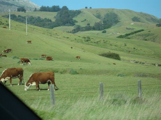
The Agricultural Core's landscape compared to Big Sur, CA is completely different. The Agricultural Core includes Wisconson, Illonis, Indiana, Ohio, Missouri, and Iowa. Flat land is one of the biggest advantages for farmers in the agricultural core, whereas Big Sur has very rugged, steep, terrain. Big Sur is better suited for vineyards, rather then dairy or corn production. However, there are a few farms in the flat areas of Big Sur which produce dairy products such as milk and cheese, also, some farms have beef as well. Big Sur's agriculture is closely tied with its history as well as building surrounding communities. 
The El Sur Ranch listed below provides dairy and beef for some of the markets in Monterey. Also, all the farms located near Big Sur help the surrounding communities with environmental and safety services. 


Agricultural History / Legacy of El Sur Ranch, Big Sur

History - Past to Present

El Sur Ranch CalfThe El Sur Ranch was originally formed as one of several hundred ranchos created during the 1800s, in California’s Spanish-Mexican period. The El Sur grant was made in 1834 by Governor Jose Figueroa to Juan Bautista Alvarado. The ranch was managed and then assumed by Alvarado’s Uncle, Captain John Rogers Cooper. Early records indicate a 5-year contract signed in 1843, to lease El Sur to John Dye, a Kentucky native who used the ranch to raise mules. In the 1850s, El Sur was again leased to dairymen who milked cows and produced cheese for the Monterey market. Cooper himself, at this point, began to use the ranch to run his own herd of beef cattle.
Until the 1920s, Cooper and his descendents, who were to become some of the largest landowners in Monterey County, continued to use El Sur and its natural meadows for beef and dairy cattle and began experimenting with agriculture along the coastal plain, including artichokes and peas. In 1928 the ranch was bought by Harry Hunt. Through the 1930s, Hunt continued agricultural uses including alfalfa, barley, corn, potatoes and carrots. It was during this period that the first irrigation centrifugal pump-wells were installed.
The land was converted back to pasture and when electricity reached Big Sur in 1948, it had the potential to be irrigated. Hunt had constructed irrigation pipelines north of Big Sur River in the early 1950s. The pipes and valves laid out in 1950 are still used on El Sur Ranch today.
In 1955, Cortlandt Hill bought El Sur Ranch from Harry Hunt. Since 1955, the Hill family has retained the property and manages the land in a manner that preserves its historic pastoral beauty, much to the benefit of Big Sur’s many sightseers.

Legacy - A Heritage of Community, Culture and Conservation

El Sur Ranch, a family owned and historic California coastal ranching operation, has since its inception, recognized its responsibility to the spectacular coastline that defines its western most boundary. El Sur Ranch’s commitment to the preservation and protection of coastal ranching and its environs has also included its role as neighbor to those within the greater Big Sur community. Examples of the Ranch’s commitment have been and continue to include the Ranch’s leadership and participation in numerous community projects such as: implementation of tree re-planting and erosion-control programs, the removal of non-native, invasive plant species, as well as involvement in a variety of scientific environmental studies that have substantially improved our understanding of this diverse and spectacular environmental resource. Source: http://elsurranch.com/historyLegacy.html
Driving to Big Sur there are many cattle farms...
Historic Property left by the Marks Family is the final piece in parkland legacy...


Carmel, CA – May 07, 2007 
Located just 3.6 miles from the heart of Salinas, the Marks Ranch property features a classic Steinbeck country landscape – gently rolling hills dotted with coastal live oaks, open meadows bursting with spring wildflowers, dense grasslands and majestic sycamores.
In 1890, Salinas Valley pioneers, Benjamin and Nisene Marks, purchased a 2000-acre property which includes the tract now known as Marks Ranch. Shortly after they settled, Benjamin Marks passed away. Nisene rose to the challenge by raising their four children and creating one of the largest egg ranches in California during the first half of the 20th century, all on her own. Source: http://www.bigsurlandtrust.org/news/show/2-the-big-sur-land-trust-preserves-opportunity-to-protect-marks-ranch
Agricultural Soils 
Compared to the agricultural soils of the Midwest, Big Sur has a vast variety of soil types with higher and lower acidity level.s Some of the soils in Big Sur are mixed with Adenostoma along with sandstone. Overall, Big Sur has a wide variety of soil types which support different plant communities. Some of the soils are limestone-derived , granitic, and metamorphic rocks- which all contribute to Big Sur's natural diversity. 
Ericoid mycorrhizas are generally ascomycetes, occasionally a basidiomycetes will show up. They are the most advanced at extracting and holding Nitrogen and Phosphorus from organic matter. They have fair drought tolerance but do best when they are on the edge of constant moisture. You will find them on the edge of high elevation or high latitude bogs, under large conifers in heavy duff next to a water source, in very high rainfall acid soil areas, next to seeps on the north slopes in heavily forested areas. (Ericoid mycorrhizas are the exception in California Natives to our watering and planting regime. They love a lot of peat and other low nitrogen organic matter worked into the soil and put on as mulch.) These mycorrhizal plants can detoxify peat. You can tweak a site to make Ericoids happy and most other things die by providing moderate moisture and 50-70% peat moss for soil, with no fertilizer or other amendments. Make sure the plant is Ericoid before you do this, other plants will decline and die.
Some California sites with ericoid plants include: Ft. Bragg area on the acid plain mixed in with the Pines, sand; above Santa Cruz mixed in with the manzanita, sand; in Big Sur mixed in with Adenostoma (of all things), sandstone; in Los Osos mixed with manzanita, sand; in the Sierras in solid stands near seeps, north slope, 6500', loamy-clay.

Adenostoma fasciculatum


Identification

Genus: Adenostoma Species: fasciculatum Variety: NoneCultivar: None
Common name: Chamise.

Click thumbnail to view larger image.
Adenostoma fasciculatum, Chamise - thumb
Adenostoma fasciculatum - thumb
A Spotted Towhee, Pipilo maculatus, on Chamise, Adenostoma fasciculatum. - thumb
Adenostoma fasciculatum, Chamise, and Trichostema lanatum - thumb
Adenostoma fasciculatum, Chamise - thumb
Adenostoma fasciculatum, Chamise flowers - thumb

Description

Chamise tends to be a medium to large shrub, 3-10 ft., tall. Native to the coast ranges (Mendocino and Lake County south to Baja) and Sierra Nevada mountains (From about Tehama County, south). a very tough plant. Used as a screen or as wind break, full sun, good drainage, erosion control, fire sensitive, can be made fairly fire resistant with a once/two week indirect watering. The Koso people used it for arrow points. The Luiseno people used it for the arrow foreshaft. Chamise Flowers sell well in the wholesale florist market. A trailing form of this plant is supposed to exist. So far, they do not trail when introduced to our heat. The trailing form doesn't have much vigor and will become upright if you let it. There are low forms in the wild growing in sand next to the coast and/or pruned regularly by Bambi, and the constant sea breezes. The full -sized form grows on both nursery sites and in our county in sand, clay, and gravel. In our area it is native to a rainfall range from 7-40 inches. Its name originates from the fascicled (clustered) leaves. Super, excellent erosion control plant. This plant is a major component of the chaparral and is holding the soil on the hillsides in California. Chamise also protects the soil after fires as it crown sprouts back from the base. A good understory plant that grows well under chamise, with a nice mulch of chamise leaves and twigs, is Viola pedunculata. Adenostema is the wrong spelling , Adenostoma is the right spelling. (Greek for the gland at the mouth of the calyx.)

Characteristics

Adenostoma fasciculatum Chamise tolerates sand and clay.
Adenostoma fasciculatum Chamise is great for a bird garden.
Adenostoma fasciculatum Chamise's foliage color is lt-green and type is evergreen.
Adenostoma fasciculatum Chamise's flower color is white.

Communities

Communities for Adenostoma fasciculatum Chamise:Chaparral and Coastal Sage Scrub.

Ranges for Adenostoma fasciculatum

ph:5.00 to 8.00
usda:6 to 10
height[m]:1.00 to 3.00
width[m]:1.00 to 2.00
rainfall[cm]:31.00 to 77.00

Source: http://www.laspilitas.com/nature-of-california/plants/adenostoma-fasciculatum


Acid rain in Big Sur – October 2010

31102010
The first rains of the season have fallen here in Big Sur and the data are rather surprising . . .

Another double acid rainbow in Big Sur
Other than the one large storm that hit last week most of the rainfall events in October were light. And they were the most acidic of any set of monthly readings since the start of the record in 2006. The rain pH of 4.1 measured on Oct 18 was the lowest pH observed in more than fours years of readings in Big Sur. The readings for Oct 23 (4.3), Oct 25 (4.4), and Oct 30 (4.4) were also unusually acidic.

Rainfall amounts and pH in Big Sur - October 2010
I’m rather at a loss for explaining this. I don’t think it’s due to higher inputs of pollution. I wonder if ocean primary productivity of the California Current is still on the rise. If so, then the greater phytoplankton activity could be enhancing amounts of dimethyl sulfide (DMS), a major precursor to sulfuric acid in the air and rain over the oceans. The figure below, from a NOAA report “Climatic and Ecological Conditions in the California Current LME for July to September 2009“, indicates that, as of last year, the chlorophyll abundance, which is a fair indicator of primary productivity, has been on the rise in recent years.
Previous and current summaries of climate and ecosystem conditions in the California Current can be found at the Pacific Coast Ocean Observing System website.

Friday, October 15, 2010

Chapter 10: The Southern Coastlands On The Subtropical Margin

Looking at the Subtropical Climate of the Southern Coastlands including Florida, Texas, and Louisiana compared to Big Sur, Ca there are many similarities and differences. Big Sur's climate is much cooler then most of the Southern Coastlands, though both regions have mild winters and long growing seasons. 

Big Sur's Climate

The proximity of the ocean modifies temperatures year round, providing a mild climate with minimal variations. Over 300 days a year of sunshine are interspersed with seasonal rains of over fifty inches a year (varying widely by exact location). Cool coastal fog often develops overnight and usually clears by midday in summer. Spring and fall bring the Sur's best weather, with clear, warm days and cool starry nights. Go inland just one or two miles and the influence of the ocean becomes abundantly clear: summer days in Big Sur's valleys often reach into the nineties while the beaches are still under wisps of fog. 

Summer - Daytime temperatures in the 80's-90's inland, 60's-70's on the coast. Nighttime temperatures range from high 40's-60's. Rarely rains in summer. Coastal fog likely.
Fall - Daytime 60-70, nights 30-40. Clear, mild weather until Thanksgiving, when rainy season begins.
Winter - Daytime 40-50, nights in the 20's and 30's. Storms are consistent, often with only a day or two between rains. But these days can be brilliant and clear.
Spring - Daytime temperatures in the 60's and 70's, sometimes warming into the 80's. Nights in the high 30's to high 40's. Rain is much less frequent.


Beaches of Big Sur
While Big Sur's beaches hardly resemble the vast stretches of sun-baked sand that dot Southern California's easily-accessible coastline, they offer the visitor a wide variety of recreational possibilities such as hiking, camping, fishing, walking near redwoods,and seeing an abundance of wildlife. 


Big Sur's beaches are warmer in the summer, though they are still cooler then most beaches. During the Summer, Big Sur can reach the ninties inland, yet still remain cooler along the coast on the beach. Seasonal fog is often along the beach and the temperatures can quickly drop. 

Due to Big Sur's steep terrain and private property almost all the beach in Big Sur require a small hike to get to. Because a majority of Bigs Sur's coastline is inaccessible, the following beaches are recommended by the State Park and U.S. Forest Service due to their easy access and breath taking scenery:


ANDREW MOLERA STATE PARK - Located 23 miles south of Carmel, Andrew Molera State Park is the largest state park on the Big Sur Coast. A wide, scenic, mile-long path leads to a sandy beach that is sheltered from the wind by a large bluff to the north. The path itself is as much a delight as the beach, taking you through a meadow filled with wildflowers and sycamore trees, offering fine views of the coastal mountain range to the east. The path parallels the Big Sur River, which enters the sea adjacent to Molera's beach.
PFEIFFER BEACH - Big Sur's most popular coastal access point, Pfeiffer Beach is hard to find if you've never been to it before. The trick is locating unmarked Sycamore Canyon Road. Here's a tip - Sycamore Canyon Road is the only paved, ungated road west of Highway One between the Big Sur post office and Pfeiffer Big Sur State Park. Once you find the turnout, make a very sharp turn. Then follow the road for about two miles until it ends. Drive carefully - this is narrow and winding road. It is unsuitable for trailer traffic. From a large parking area at the end of the road, a short, well-marked path leads to the beach. Cliffs tower above this breathtaking stretch of sand, and a large arch-shaped rock formation just off-shore makes for some dazzling sunsets.
JULIA PFEIFFER BURNS STATE PARK - Julia Pfeiffer Burns State Park stretches from the Big Sur coastline into nearby 3,000-foot ridges. The park features redwood, tan oak, madrone, chaparral, and an 80-foot waterfall that drops from granite cliffs into the ocean from the Overlook Trail. A panoramic view of the ocean and miles of rugged coastline is available from the higher elevations along the trails east of Highway 1. The park is 37 miles south of Carmel on Highway One; 12 miles south of Pfeiffer Big Sur State Park. (not to be confused with Julia Pfeiffer Burns State Park).
SAND DOLLAR BEACH - Just a mile south of the U.S. Forest Service Station in Pacific Valley and 14 miles north of the San Luis Obispo County line lies Sand Dollar Beach

Source:http://www.californiaweekend.com/cities.php?city=Big%20Sur


Agriculture

Big Sur has some small farms, and vineyards but most agriculture is grown more inland outside of Monterey, CA. One of the neighboring cities of Big Sur is Salinas Valley which is known as "The Salad Bowl of the World." Agriculture dominates the economy of the valley due to their warm weather and long growing seasons. Salinas Valley produces lettuce, broccoli, peppers and numerous other crops. The climate is also ideal for the floral industry and grape vineyards planted by world-famous vintners. Other dominate crops in Salinas Valley include strawberries, tomatoes, and spinach. Furthermore, a 
large majority of the salad greens consumed in the U.S. are grown within this region.[1]  

The climate is precise to grow these crops, and Salinas Valley has an extended period of time in which crops can be grown compared to more northern regions where the winter causes quite an obstacle to farmers.

Source: http://en.wikipedia.org/wiki/Salinas_Valley


Weather Hazards:
The weather hazards of the Southern Coastlands are more sporadic, dramatic, and locally destructive compared to Northern CA. Hurricanes along the coastland are due to the regions intense solar heating over large bodies of warm water. Big Sur, CA however, does not get hurricanes and is subjected to forest fires in the summer months due to dry vegetation and high temperatures.

Big Sur's Fires

Source: http://www.telegraph.co.uk/news/worldnews/northamerica/usa/2242343/Fire-closes-in-on-Californias-Big-Sur-coast.html


Source: http://bigsurkate.wordpress.com/2010/08/03/gree-fire-in-big-sur/
Basin Complex Fire Near Big Sur, California

Source: http://earthobservatory.nasa.gov/IOTD/view.php?id=8880


Source: http://www.dmtimaging.com/bigsurfire.htm


Friday, October 8, 2010

Chapter 9: The Changing South

Every geographic area can be viewed as a geographic composite of attitudes, and patterns. Big Sur has come to take on the personality of a retreat into paradise. Many of the locals who live here are artists, writers, photographers, farmers, and vacation home owners. Artists frequently sell their work at local gift shops, restaurants, and resorts such as the Post Ranch Inn.


http://www.dailyartpainters.com/2008/jul/09/2008-07-09-maryanne-jacobsen.htm


Big Sur Population

QuickFacts
Population:940
Pop. Change:-6%
State:California
Metro Area:Salinas Metro Area
County:Monterey County
City:No City
Zip Code:Big Sur (zip 93920)
Real Estate:For Sale
Search:Find and Compare Realtors
Map Of Big_Sur

Zip Code Overview

As of 2010, Big Sur (zip 93920)'s population is 940 people. Since 2000, it has had a population growth of -6.09 percent.

The median home cost in Big Sur (zip 93920) is $635,780. Home appreciation the last year has been -8.66 percent.

Compared to the rest of the country, Big Sur (zip 93920)'s cost of living is 93.10% Higher than the U.S. average.

Big Sur (zip 93920) public schools spend $12,128 per student. The average school expenditure in the U.S. is $5,678. There are about 6.8 students per teacher in Big Sur (zip 93920).

The unemployment rate in Big Sur (zip 93920) is 10.60 percent(U.S. avg. is 10.20%). Recent job growth is Negative. Big Sur (zip 93920) jobs have Decreased by 3.55 percent.


Many festivals have been held in Big Sur over the years due to its artistic and laid back reputation.


Joni Mitchell, Big Sur Folk Festival, 1969

Big Sur Folk Festival,1970


Jade Festival, Big Sur, 2009

http://www.timelessjade.com/2009/10/24/big-sur-jade-festival-2009/


Arts Festival, Big Sur, 2009

http://www.esalen.org/archive/artsfestival2009/index.html


Food & Wine Festival, Big Sur, 2009

http://blog.ridgewine.com/2009/11/06/do-you-know-the-way-to-big-sur-or-big-sur-wine-food-festival/


http://guedelhudos.blogspot.com/2008_06_01_archive.html


Thursday, October 7, 2010

Chapter 8: Appalachia and The Ozarks


USGS BIG SUR Quad, California, Topographic Map

BIG SUR quad is a topographic map (topo) in the state of California (CA), located at latitude - longitude coordinates (also known as lat-long or GPS coordinates) of N 36.31246 and W -121.81356. BIG SUR is sourced from the USGS (United States Geographical Survey). The nearest major town is Carmel Valley, CA. Source:http://www.topozone.com/map.asp?lon=-121.8125&lat=36.3125

Locator Map

Projection: NAD83/WGS84


MINING METHODS
  • The Big Sur region has very little mining history. Historically in the late 1880s, there was limestone extraction in LimeKiln Creek by the Rockland Lime and Lumber Company and in Bixby Creek. 
  • The only large-scale mining operation in Big Sur is the limestone quarry located on the South face of Pico Blanco by the Granite Rock Company. Pio Blanco is a prominent landmark just inside the Los Padres National Forest, its white limestone peak visible from heavily traveled state Highway 1.The Granite Rock mining project is regarded as one of the highest-grade limestone operations in the country. Limestone is used in products ranging from concrete to toothpaste whitener.The company began mining the area in 1981, obtaining approval under an 1872 federal law. 
  • The surrounding forests felt a greater impact due to large amounts of trees being cut down to fuel the kilns. 
  • Farther South, there was a brief gold rush in the head waters of Alder Creek.
  • Today, a few small jade and gold claims exist in the National Forest, and diving for jade has become increasingly popular. 
  • Source: http://books.google.com/booksid=7iqPlVKxdSQC&pg=PA282&lpg=PA282&dq=Big+Sur+mining&source=bl&ots=ObqQi9KEcb&sig=aBvDW1Gn6FS1wAQ9q4w2wEnI_0&hl=en&ei=LEW6TPziLpK6sQPCsLn5DA&sa=X&oi=book_result&ct=result&resnum=1&sqi=2&ved=0CBIQ6AEwAA#v=onepage&q=Big%20Sur%20mining&f=false

BIG SUR BACKCOUNTRY-The Ventura Wilderness

Containing 167,323 acres, Ventana Wilderness straddles the Santa Lucia Mountains south of the Monterey Peninsula. This unique area of rugged coastal mountains is managed by the United States Forest Service.

Topography in the Wilderness is characterized by steep-sided, sharp-crested ridges separating V-shaped valleys. Elevations range from 600 feet, where the Big Sur River leaves the wilderness, to about 5,750 feet at the wilderness boundary circumventing Junipero Serra Peak. Most streams fall rapidly through narrow vertical-walled canyons flowing on bedrock or a veneer of boulders. Waterfalls, deep pools and thermal springs are found along major streams.


Regional Development Programs


The Big Sur Land Trust:
It is through the generosity of our donors that The Big Sur Land Trust has been able to make such a significant and positive impact on Monterey County’s landscapes and communities. With your help The Big Sur Land Trust has protected more than 30,000 acres of shoreline, wildlife habitat, streams, forests, grasslands, parklands and awe-inspiring views.
Donate 7 2 2

The Big Sur Land Trust believes that everyone in Monterey County has a stake in the health of our lands and waters, especially our children and our children’s children. Ensuring their future requires cultivating a shared commitment to stewardship of our region’s lands and waters.