Looking at the Subtropical Climate of the Southern Coastlands including Florida, Texas, and Louisiana compared to Big Sur, Ca there are many similarities and differences. Big Sur's climate is much cooler then most of the Southern Coastlands, though both regions have mild winters and long growing seasons.
 Big Sur's Climate
The proximity of the ocean modifies temperatures year round, providing a mild climate with minimal variations. Over 300 days a year of sunshine are interspersed with seasonal rains of over fifty inches a year (varying widely by exact location). Cool coastal fog often develops overnight and usually clears by midday in summer. Spring and fall bring the Sur's best weather, with clear, warm days and cool starry nights. Go inland just one or two miles and the influence of the ocean becomes abundantly clear: summer days in Big Sur's valleys often reach into the nineties while the beaches are still under wisps of fog.

Summer - Daytime temperatures in the 80's-90's inland, 60's-70's on the coast. Nighttime temperatures range from high 40's-60's. Rarely rains in summer. Coastal fog likely.
Fall - Daytime 60-70, nights 30-40. Clear, mild weather until Thanksgiving, when rainy season begins.
Winter - Daytime 40-50, nights in the 20's and 30's. Storms are consistent, often with only a day or two between rains. But these days can be brilliant and clear.
Spring - Daytime temperatures in the 60's and 70's, sometimes warming into the 80's. Nights in the high 30's to high 40's. Rain is much less frequent.
Beaches of Big Sur
While Big Sur's beaches hardly resemble the vast stretches of sun-baked sand that dot Southern California's easily-accessible coastline, they offer the visitor a wide variety of recreational possibilities such as hiking, camping, fishing, walking near redwoods,and seeing an abundance of wildlife.
Big Sur's beaches are warmer in the summer, though they are still cooler then most beaches. During the Summer, Big Sur can reach the ninties inland, yet still remain cooler along the coast on the beach. Seasonal fog is often along the beach and the temperatures can quickly drop.
Due to Big Sur's steep terrain and private property almost all the beach in Big Sur require a small hike to get to. Because a majority of Bigs Sur's coastline is inaccessible, the following beaches are recommended by the State Park and U.S. Forest Service due to their easy access and breath taking scenery:
ANDREW MOLERA STATE PARK - Located 23 miles south of Carmel, Andrew Molera State Park is the largest state park on the Big Sur Coast. A wide, scenic, mile-long path leads to a sandy beach that is sheltered from the wind by a large bluff to the north. The path itself is as much a delight as the beach, taking you through a meadow filled with wildflowers and sycamore trees, offering fine views of the coastal mountain range to the east. The path parallels the Big Sur River, which enters the sea adjacent to Molera's beach.
PFEIFFER BEACH - Big Sur's most popular coastal access point, Pfeiffer Beach is hard to find if you've never been to it before. The trick is locating unmarked Sycamore Canyon Road. Here's a tip - Sycamore Canyon Road is the only paved, ungated road west of Highway One between the Big Sur post office and Pfeiffer Big Sur State Park. Once you find the turnout, make a very sharp turn. Then follow the road for about two miles until it ends. Drive carefully - this is narrow and winding road. It is unsuitable for trailer traffic. From a large parking area at the end of the road, a short, well-marked path leads to the beach. Cliffs tower above this breathtaking stretch of sand, and a large arch-shaped rock formation just off-shore makes for some dazzling sunsets.
JULIA PFEIFFER BURNS STATE PARK - Julia Pfeiffer Burns State Park stretches from the Big Sur coastline into nearby 3,000-foot ridges. The park features redwood, tan oak, madrone, chaparral, and an 80-foot waterfall that drops from granite cliffs into the ocean from the Overlook Trail. A panoramic view of the ocean and miles of rugged coastline is available from the higher elevations along the trails east of Highway 1. The park is 37 miles south of Carmel on Highway One; 12 miles south of Pfeiffer Big Sur State Park. (not to be confused with Julia Pfeiffer Burns State Park).
SAND DOLLAR BEACH - Just a mile south of the U.S. Forest Service Station in Pacific Valley and 14 miles north of the San Luis Obispo County line lies Sand Dollar Beach
Source:http://www.californiaweekend.com/cities.php?city=Big%20Sur
Agriculture
Big Sur has some small farms, and vineyards but most agriculture is grown more inland outside of Monterey, CA. One of the neighboring cities of Big Sur is Salinas Valley which is known as "The Salad Bowl of the World." Agriculture dominates the economy of the valley due to their warm weather and long growing seasons. Salinas Valley produces lettuce, broccoli, peppers and numerous other crops. The climate is also ideal for the floral industry and grape vineyards planted by world-famous vintners. Other dominate crops in Salinas Valley include strawberries, tomatoes, and spinach. Furthermore, a
The climate is precise to grow these crops, and Salinas Valley has an extended period of time in which crops can be grown compared to more northern regions where the winter causes quite an obstacle to farmers.
Source: http://en.wikipedia.org/wiki/Salinas_Valley
Weather Hazards:
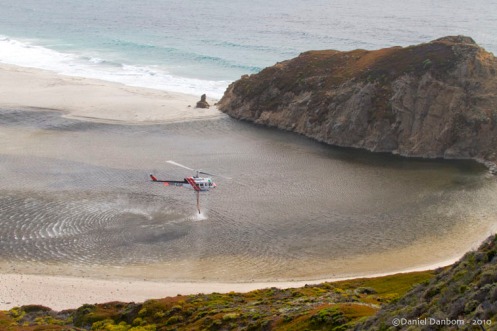
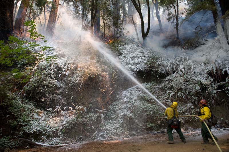
The weather hazards of the Southern Coastlands are more sporadic, dramatic, and locally destructive compared to Northern CA. Hurricanes along the coastland are due to the regions intense solar heating over large bodies of warm water. Big Sur, CA however, does not get hurricanes and is subjected to forest fires in the summer months due to dry vegetation and high temperatures.
Big Sur's Fires

Source: http://www.telegraph.co.uk/news/worldnews/northamerica/usa/2242343/Fire-closes-in-on-Californias-Big-Sur-coast.html

Source: http://bigsurkate.wordpress.com/2010/08/03/gree-fire-in-big-sur/
Basin Complex Fire Near Big Sur, California

Source: http://earthobservatory.nasa.gov/IOTD/view.php?id=8880

Source: http://www.dmtimaging.com/bigsurfire.htmWeather Hazards:
The weather hazards of the Southern Coastlands are more sporadic, dramatic, and locally destructive compared to Northern CA. Hurricanes along the coastland are due to the regions intense solar heating over large bodies of warm water. Big Sur, CA however, does not get hurricanes and is subjected to forest fires in the summer months due to dry vegetation and high temperatures.
Big Sur's Fires

Source: http://www.telegraph.co.uk/news/worldnews/northamerica/usa/2242343/Fire-closes-in-on-Californias-Big-Sur-coast.html

Source: http://bigsurkate.wordpress.com/2010/08/03/gree-fire-in-big-sur/
Basin Complex Fire Near Big Sur, California

Source: http://earthobservatory.nasa.gov/IOTD/view.php?id=8880

No comments:
Post a Comment