Tuesday, December 7, 2010

Chapter 18: Hawaii

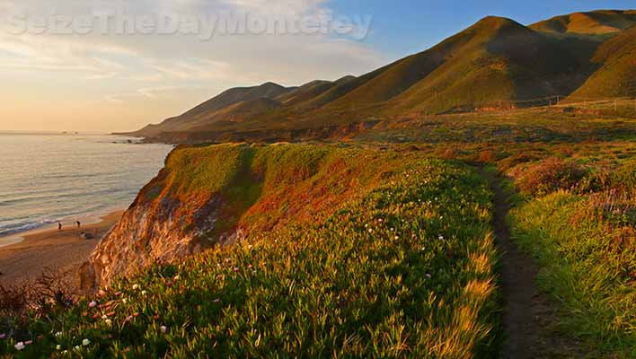
The Location and Physical Setting of Big Sur reminds me of Hawaii...
Hawaii is in the middle of the Pacific Ocean , while Big Sur is on the Coast
Hawaii and Big Sur's locations are both relatively isolated
Hawaii's geology shows visible volcanoes and Big Sur's geology 
includes some of the most abrupt elevation changes on the entire Pacific Coastline.


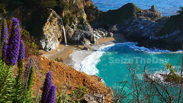
McWay Falls at Pfeiffer Beach in Big Sur, CA reminds me of Hawaiian Paradise...
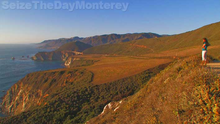


Big Sur Geology

The mountains of the rugged Big Sur coastline rise to 5,000 foot summits within two miles of the ocean, the most abrupt elevation change of the entire Pacific shore.

Several hundred million years ago, river-borne sediments from a mountain range in what is now Mexico were deposited along the western coast. These layers of sandstone, siltstone and limestone were compressed and folded by the underriding of tectonic plates at the continent's edge. The sediments metamorphosed with pressure into schist, gneiss, granofels and marbles--now the oldest rocks in the Santa Lucia range.
By sixty five million years ago, this plate -- called the Salinan block -- began to drift northward. In response to the clockwise rotation of the Pacific Ocean's crust, the block was temporarily halted in its smooth progress and became jostled with faulting and uplifting, a process that still continues today. Seismic activity along the many faults is common as the mountains continue to be uplifed. Stream canyons frequently follow fault lines. Lateral faults are in the majority here, hence, most canyons parallel the coast rather than descend directly to it.
The highest peaks visible are granitic rock, which tends to be more resistant to erosion. In places where stream erosion was minor, the taller peaks may also be marble (metamorphosed limestone)--Pico Blanco is one such marble summit. The original sediments of sandstone and siltstone have been tilted up into cliffs in some areas. The sculpted shapes at Point Lobos are rare local examples of conglomerate formations.

Source: http://www.bigsur-coastline.com/geology.html

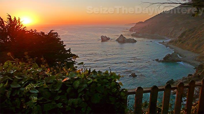
Pfeiffer Beach at Sunset...


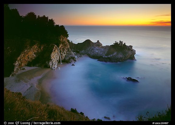
Source: http://www.terragalleria.com/california/picture.usca20497.html


Morro Rock is one of a line of ancient volcanic intrusions or plugs sometimes called the Seven Sisters or The Nine Morros, depending on how many of the peaks are included in the count.


Morro Rock, Morro Bay CA near Big Sur


Source: http://patricksmithphotography.smugmug.com/Landscapes/California-Big-Sur-South/14079881_GcJrg


Evidence supports a theory that the morros erupted along old fault lines, leading to a hot spot deep within the earth. Morro Rock is dated to about 22 million years old. Black Hill, rising behind the Morro Bay Golf Course, and Hollister Peak are about 28 million years old during the Oligocene epoch of geologic history. The Morros may have formed south of the region with their remnants moving along the San Andreas fault to their current positions. 

Many other changes took place over the millions of years since Morro Rock solidified. About eighteen to twenty thousand years ago, the sea was 300 feet lower than it is today. Morro Rock stood on dry land. After the last glacial retreat, the sea rose again and Morro Rock was surrounded by salt water. A causeway to Morro Rock was made in 1933 through the Works Progress Administration. A causeway was created with materials blasted from the rock. 

The volcanic plugs tend to have steep sides of exposed rock, although buttresses slope from these peaks to make all of them accessible.  The Chorro Valley surrounds the Morros and features several hundred Chumash Indian mortar sites. If you would like to learn more about the history and geology of Morro Rock and other morros, visit the Morro Bay Museum of Natural History. 

Chapter 16: The North Pacific Coast

 According to the text, Regional Landscapes of the United States and Canada,  in "northern California and sourthern Oregon, the Klamath Mountains offer a jumbled topographyy that is a product of Pleistoscene glaciation and steam erosion. " (Birdsall pg 326) This is why the rugged coastline of the North Pacific Coast is very similar to Big Sur's coastline. Both have rocky coastlines with amazing natural landscapes, along with gorgeous mountains and cliffs over the ocean. However, both regions also get a lot of rain, though Oregon receives more on average compared to Big Sur. 

Big Sur storm total: 21.34 inches of rain at Mining Ridge

 BigSurKate reports 8.6 inches so far at her location in today's storm, 10 inches at Mining Ridge, which is 4.5 miles NW of Cone Peak.


Source: http://www.flickr.com/photos/selago/4009254455/

Landslides may result from too much rain along Coastal areas in Big Sur:


U.S. Geological Survey 
Scientific Investigations Map 2852 

Maps Sh Estimated Sediment Yield From Coastal Landslides and Active Slope Distribution Along the Big Sur Coast, Monterey and San Luis Obispo Counties, California

By Cheryl J. Hapke, Krystal R. Green, and Kate Dallas

2004

three maps of the coast showing erosion information


The 1982-83 and 1997-98 El NiƱos brought very high precipitation to California’s central coast; this precipitation resulted in raised groundwater levels, coastal flooding, and destabilized slopes throughout the region. Large landslides in the coastal mountains of Big Sur in Monterey and San Luis Obispo Counties blocked sections of California State Route 1, closing the road for months at a time. Large landslides such as these occur frequently in the winter months along the Big Sur coast due to the steep topography and weak bedrock. A large landslide in 1983 resulted in the closure of Highway 1 for over a year to repair the road and stabilize the slope. Resulting work from the 1983 landslide cost over $7 million and generated 30 million cubic yards of debris from landslide removal and excavations to re-establish the highway along the Big Sur coast.

Chapter 15: California

Big Sur offers some of the most spectacle views along the California Coast...

Things You Absolutely Have to do in Big Sur California!

Big Sur California, Mcway Falls is an absollute must do!
Are you looking forward to your Big Sur California trip? I bet you are and for good reason, there is lots to see, do, and experience. So you have your Big Sur Lodging squared away, you’ve checked out my driving tips, and now you’re looking for things to do.
Well, check out my must do list below for some ideas:

Things You Simply Must Do In Big Sur California:

Big Sur offers some of the best and most scenic hikes in California.

Hike the hikes that Big Sur California is known for, be it the easy or challenging ones! The goregeous view above is from the overlooking bluffs at Garrapata State Beach. This trail will lead you to a small canyon where the Doud Creek flows to the Pacific Ocean. Here is where you’ll find hundreds of blooming Calla Lillies depending on the time of year. Please don’t pick them, let others enjoy them too!


The Sea Otter is one of the most popular animals in all of Big Sur!

Witness Big Sur’s Magnificent Wildlife such as Sea Otters (above), Monarch Butterflies, Migrating Whales, Harbor Seals, Sea Lions, Great Blue Herons, and so much more! Find out the Best Spots to See Big Sur California Wildlife


Big Sur California Hurricane Point is a sight for sore eyes
Don’t miss the Best Big Sur California Sight Seeing Spots such as Bixby Bridge, China Cove Beach, McWay Falls, and Hurricane Point (pictured above) and so much more!


Glorious Sunsets in Big Sur are hard to beat
Watch a glorious Sunset from one of the Best Places in Big Sur to Watch the Sun go Down! See why McWay Falls (pictured above) and Pfeiffer Beach are two of the best places to watch sunsets!


China Cove at Point Lobos State Reserve in Big Sur is a "Cannot Miss"
Did You Know that Point Lobos State Reserve inspired the classic novel "Treasure Island"? You’ll realize why once you set foot on this amazingly beautiful park. It is hard to truly describe how magical Point Lobos is. Truly set aside at least 2-3 hours to check out one of my highest recommended things to do in Big Sur California and all of Monterey!


Big Sur California, Mcway Falls Waterfall pours onto a serene beach which washes away into the Pacific Ocean.
Take an easy five minute hike to experience the Crown Jewel of Big Sur California: McWay Falls at Julia Pfeiffer Burns State Park. If you could only stop and see one thing in all of Big Sur California, make sure it is McWay Falls!


Big Sur California, Seal Pupping at Point Lobos State Reserve
Are you visiting Big Sur California during March or April? Then you have to head down to the
Point Lobos State Reserve and see the Seals Pupping. You’ll get great views of the seals on the beach at Whalers Cove and China Cove Beach. Time will stand still while you’re watching the young pups play in the water with their mothers.


Big Sur California Sunset

Watch the Sunrise and/or Sunset from a Horseback Tour to the Beach! That’s right, you can take a horseback tour to the beach in Big Sur California. You’ll get to witness a glorious sunrise or sunset from horseback. And of course there are mid-day tours as well!


Source: http://big-sur-lodging.com/Big-Sur-California-Visitor-Guide/Pacific-Coast-Highway-Photo-Tour/pg-Big_Sur_CA_PCH-1_Vacation_Gallery/30-Sand_Dollar_Beach_California_Picnic_Day_Use.htm

California's Water Supply...


Source:http://taxdollars.ocregister.com/2009/02/23/water-survey/9578/


Big Sur is impacted with California's water supply shortage.  However, it is not affected the same same as Monterey Country. Unlike other portions of Monterey County, Big Sur already has the rural means of dealing water, sewage, and rain run off- which are not an issue for them. Instead Big Sur lacks the capacity and space regarding this issue.

California gets most of its water from Colorado...

Source: http://www.crwr.utexas.edu/gis/gishydro06/Introduction/TermProjects/Danner.htm


Source: http://article.wn.com/view/2010/12/03/Big_Sur_Land_Trust_buys_coveted_ranch_near_Carmel/


Water Discharge, cubic feet per second
Most recent instantaneous value: 40   12-07-2010  09:15 PST
Graph of  Discharge, cubic feet per second    
Create presentation-quality / stand-alone graph.   Subscribe to WaterAlert Introduction page WaterAlert      
Daily discharge statistics, in cfs, for Dec 7 based on 59 years of record more
Min
(1991)
25th
percen-
tile
MedianMost Recent
Instantaneous
Value Dec 7
75th
percen-
tile
MeanMax
(1967)
6.319294075981170

Gage height, feet
Most recent instantaneous value: 4.58   12-07-2010  09:15 PST
Graph of  Gage height, feet    
Create presentation-quality / stand-alone graph.   Subscribe to WaterAlert Introduction page WaterAlert
Source: http://waterdata.usgs.gov/usa/nwis/uv?11143000