Thursday, October 7, 2010

Chapter 8: Appalachia and The Ozarks


USGS BIG SUR Quad, California, Topographic Map

BIG SUR quad is a topographic map (topo) in the state of California (CA), located at latitude - longitude coordinates (also known as lat-long or GPS coordinates) of N 36.31246 and W -121.81356. BIG SUR is sourced from the USGS (United States Geographical Survey). The nearest major town is Carmel Valley, CA. Source:http://www.topozone.com/map.asp?lon=-121.8125&lat=36.3125

Locator Map

Projection: NAD83/WGS84


MINING METHODS
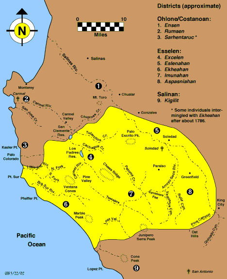
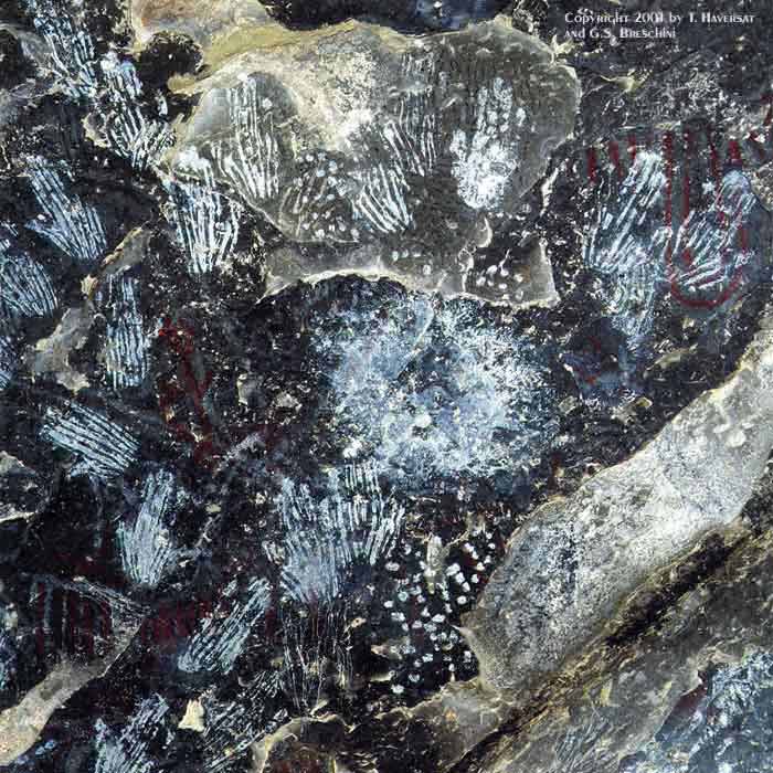
  • The Big Sur region has very little mining history. Historically in the late 1880s, there was limestone extraction in LimeKiln Creek by the Rockland Lime and Lumber Company and in Bixby Creek. 
  • The only large-scale mining operation in Big Sur is the limestone quarry located on the South face of Pico Blanco by the Granite Rock Company. Pio Blanco is a prominent landmark just inside the Los Padres National Forest, its white limestone peak visible from heavily traveled state Highway 1.The Granite Rock mining project is regarded as one of the highest-grade limestone operations in the country. Limestone is used in products ranging from concrete to toothpaste whitener.The company began mining the area in 1981, obtaining approval under an 1872 federal law. 
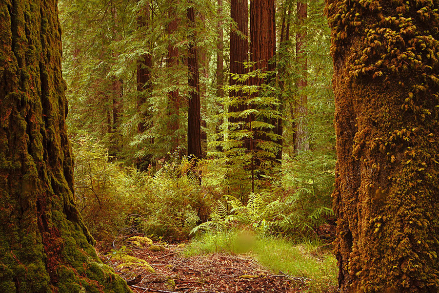
  • The surrounding forests felt a greater impact due to large amounts of trees being cut down to fuel the kilns. 
  • Farther South, there was a brief gold rush in the head waters of Alder Creek.
  • Today, a few small jade and gold claims exist in the National Forest, and diving for jade has become increasingly popular. 
  • Source: http://books.google.com/booksid=7iqPlVKxdSQC&pg=PA282&lpg=PA282&dq=Big+Sur+mining&source=bl&ots=ObqQi9KEcb&sig=aBvDW1Gn6FS1wAQ9q4w2wEnI_0&hl=en&ei=LEW6TPziLpK6sQPCsLn5DA&sa=X&oi=book_result&ct=result&resnum=1&sqi=2&ved=0CBIQ6AEwAA#v=onepage&q=Big%20Sur%20mining&f=false

BIG SUR BACKCOUNTRY-The Ventura Wilderness

Containing 167,323 acres, Ventana Wilderness straddles the Santa Lucia Mountains south of the Monterey Peninsula. This unique area of rugged coastal mountains is managed by the United States Forest Service.

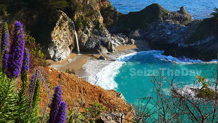
Topography in the Wilderness is characterized by steep-sided, sharp-crested ridges separating V-shaped valleys. Elevations range from 600 feet, where the Big Sur River leaves the wilderness, to about 5,750 feet at the wilderness boundary circumventing Junipero Serra Peak. Most streams fall rapidly through narrow vertical-walled canyons flowing on bedrock or a veneer of boulders. Waterfalls, deep pools and thermal springs are found along major streams.


Regional Development Programs


The Big Sur Land Trust:
It is through the generosity of our donors that The Big Sur Land Trust has been able to make such a significant and positive impact on Monterey County’s landscapes and communities. With your help The Big Sur Land Trust has protected more than 30,000 acres of shoreline, wildlife habitat, streams, forests, grasslands, parklands and awe-inspiring views.
Donate 7 2 2

The Big Sur Land Trust believes that everyone in Monterey County has a stake in the health of our lands and waters, especially our children and our children’s children. Ensuring their future requires cultivating a shared commitment to stewardship of our region’s lands and waters. 

Chapter 7: The Bypassed East

Big Sur is similar to the Bypassed East because it is located near major transportation routes but not on them...
Located right off Highway 1 Big Sur is only accessible through the Highway via driving, riding a bike or taking the Monterey Bus.


The Physical Environment:
The terrain offers stunning views, making Big Sur a popular tourist destination. Big Sur's Cone Peak is the highest coastal mountain in the contiguous 48 states, ascending nearly a mile (5,155 feet/1571 m) above sea level, only three miles (4.8 km) from the ocean.Source: http://en.wikipedia.org/wiki/Big_Sur
Climate:
Due to Big Sur's close proximity to the ocean modifies temperatures year round, providing a mild climate with minimal variations. Over 300 days a year of sunshine with seasonal rains. Cool coastal fog often develops overnight and usually clears by midday in summer. Spring and fall are usually Big Sur's best weather, with clear, warm days and cool starry nights. Go inland just one or two miles and the influence of the ocean becomes abundantly clear: summer days in Big Sur's valleys often reach into the nineties while the beaches are still filled with fog. 
Agriculture:
Big Sur has many ranches, and forests, but mostly farmers sell their produce at local farmers markets in Big Sur, Carmel and Monterey. Also, many local restaurants buy most of their fresh food from local farmers and some places even ship certain products such as honey and wine across the US. 


Franklin Peace’s Big Sur Story:


Small_frank_peace_1


When Franklin Peace’s father caught a loose swarm of bees in Monterey in 1940, little did young Franklin suspect that this event would lead him to a lifetime of beekeeping and honey-gathering in Big Sur. 
. .That was in 1950, the property was Glen Deven Ranch, and sixty years later Franklin’s hives are still there. In 2001, Dr. Seeley and Virginia Mudd bequeathed Glen Deven Ranch to The Big Sur Land Trust.

Small_gdview
“Glen Deven is a good place for bees,” Peace, who is 83, now says. “The hillside above is all sagebrush, which makes for the best honey in California.”
At one time, Peace had a hundred hives going. He would sell honey to hotels and restaurants in Big Sur as well as to a supermarket in Santa Cruz. 
Peace understands the value of bees and beekeeping. “Bees are good for the soil, good for pollination,” he says. Beekeeping affords him a deep connection to both land and community.


Wednesday, October 6, 2010

Chapter 5: The North American Manufacturing Core


http://farm4.static.flickr.com/3297/3539608557_f3ca9db28f.jpg

Big Sur is mostly known for its gorgeous views, amazing hikes, great camping, and natural hot springs with beautiful resorts; where many people escape from their busy lives for a rest and relax vacation. Big Sur is often seen as a retreat for many artists, writers, and nature lovers. The "town" itself is very small and mostly gets vistiors due to Highway 1. There are approximatly nine grocery stores, seven gas stations and a few gift shops scattered along the length of Highway 1. 

http://i.telegraph.co.uk/telegraph/multimedia/archive/01471/big-sur460_1471437c.jpg

Manufacturing in Big Sur

Today, the tan bark, lumber and limestone industries have ceased. Gold is still mined on a limited basis in the Los Burros region and a few trees are harvested along the coast. Ranching continues as the major use of the large private holdings and contributes much to the character of Big Sur. Public recreation and private residential development are by far the strongest land use trends today.Single family residences comprise a major developed land use on private land. This occurs either in rural residential clusters in areas where development has historically been concentrated or scattered along Highway One. Many of the larger parcels are used for cattle grazing. Commercial uses, including restaurants, grocery stores and service stations are generally concentrated in the Big Sur Valley, Gorda and a few isolated businesses along Highway One. Recreational uses include public and private campgrounds, visitor accommodations, restaurants, State Park units and the Los Padres National Forest. 
http://www.bigsurhomes.com/big_sur_development_history.htm


While Big Sur is not known for its manufacturing, we can still see the effects Highway 1 has had on the region. Highway 1 expanded the economic growth of Big Sur as well as the surrounding cities of Monterey, and Carmel. Before Highway 1, many people could not reach Big Sur safely, afterwards travel greatly increased and now millions of people from around the United States come to see Big Sur's Landmarks. Currently there is little manufacturing in Big Sur, because it is mainly known for its wide open spaces, highly priced vacation homes, and natural landmarks. 

TRANSPORTATION IN BIG SUR:
There is one public bus that goes through Big Sur, the Monterey-Salinas Transit Route 22. The bus route is active daily from Memorial Day through Labor Day and weekends only the rest of the year. It goes from downtown Monterey to Big Sur and back four times a day, stopping at several state parks, the Big Sur River Inn, and Nepenthe. During the winter and spring, the bus is sometimes canceled due to bad weather.
Private driving along Highway 1 is the most common mode of transportation.
Bicycling along Highway 1 is also popular, though challenging.
Much of the interior areas of the region are only accessible via hiking.


Natural Landmarks in Big Sur:

 Other Landmarks Include:


Tuesday, October 5, 2010

Chapter 4: Megalopolis

According to Birdsall, Stephen S. "Chapter 4: Megalopolis." Regional Landscapes of the United States and Canada. 7th ed. Chichester: John Wiley & Sons, 2009. 64+. Print. "The primary theme of Megapolis is its urban-ness. In varying degrees, urban activities like municipal utilities, fire and police protection provide for the people who live there". 
California itself is a big Megapolis, with each major city effecting smaller surrounding cities. For example, as Los Angeles grew, its growth promoted new areas of revenue within smaller surrounding cities. Big Sur however is relatively isolated compared to most cities within California. Located near Monterey and Carmel, Big Sur is a small "town" with its own volunteer Fire Department, 24 hour Sheriff, Highway Patrol, and Park Rangers. In addition, Big Sur has emergency medical support, cliff rescue, and a locally based ambulance service. Monterey is the closest major city to Big Sur and therefore, helps to provide services and support if needed. For example, when calling 911, your call will be routed through Monterey County dispatch center and directed to emergency services in Big Sur. This is because Monterey County houses the urban activities and resources needed for smaller surrounding "towns" and cities. 

Big Sur Map
http://www.bigsurcalifornia.org/map.html
Changes in Population Redistribution
The history of development in Big Sur reflects the changing demands for use of the land. Subsistence ranching, logging of redwoods, harvesting tan bark and mining of limestone and gold provided a livelihood for early residents. While life was extremely rugged in these early years, there was a population of nearly 1,000 people by the 1880's largely supported by these basic industries. The mountain terrain, numerous deep canyons and lack of roads made travel difficult and slow. Most local products were shipped out by sea on the small coastal trading vessels that brought supplies to the isolated coast's residents. Palo Colorado Canyon, Notley's Landing, Bixby Creek, the Big Sur Valley and Partington Canyon were early centers of activity. Around the turn of the century, limited recreational use of the coast began to occur. The Big Sur Valley could be reached by stage from Monterey and camping in the redwood groves grew in popularity. Hunting and trout fishing were also popular and some local residents supplemented their income by guiding sportsmen from the cities.


The Big Sur Valley, Lucia and Gorda have significant residential use, although the primary functions of these areas are community service and commercial.
As a recreational area of regional, national and international importance, Big Sur attracts nearly 4.5 million visitors annually. The accessibility of Big Sur  to several nearby population centers is a major factor contributing to its high visitation. The basic recreational resource of Big Sur is the visual beauty of its striking landforms and unspoiled landscape. The mountains, forests, creeks, rivers and ocean shoreline combine to offer diverse recreational opportunities. The artistic and rustic lifestyle for which Big Sur is known creates an attractive cultural setting that compliments the natural character of the area.
Recreational activity is concentrated along the coastal strip: on beaches, rocky shoreline, public parks, forest lands, campgrounds off Highway One and various visitor serving facilities.


Approximately 2/3 of the Big Sur coastal zone is in public ownership under the U.S. Forest Service, the State Department of Parks and Recreation, the  U.S. Navy, the U.S. Coast Guard and the University of California. If public acquisitions now contemplated or in progress are completed, approximately 60% of the coast will be publicly owned. Some of the private lands have scenic easements or deed restrictions, which limit the level of development.

Sunday, October 3, 2010

Chapter 3: Foundations of Human Activity

Piedras Blancas Lighthouse
http://www.bigsurcalifornia.org/piedras.html 
BIG SUR NATIVE AMERICAN HISTORY 
Three Native American tribes were the first people to inhabit the area now known as Big Sur: the Ohlone, Esselen, and Salinan. Archaeological evidence shows that they lived in Big Sur for thousands of years, leading a nomadic, hunter-gatherer existence. Few  traces of their material culture have survived. Their arrow heads were made of obsidian, which indicates trading links with tribes hundreds of miles away, since the nearest sources of obsidian are in the Sierra Nevada mountains and the northern California Coast Ranges. Large exposed rocks hollowed out into bowl shapes that were used to grind acorns into flour, can still be found at sites throughout Big Sur today.History of the Esselen Indians
The Esselen are often cited as the first California group to become culturally extinct;1840s
 a  Esselen map


There were five Esselen districts: Excelen, Eslenahan, Imunahan, Ekheahan, and Aspasniahan (see map). Each of these districts occupied a fairly specific territory with generally-recognized boundaries, and most likely had a reasonably stable resident population. Within each district there were a number of villages which were sequentially occupied on a seasonal basis depending on the availability of resources such as food, water, shelter, and firewood. Of these five districts, the boundaries of the Excelen district are probably the best known. The least known boundaries are in the mountainous areas between Excelen, Imunahan, and Ekheahan.Population- It is estimated the Esselen population was approximately 550-1000.  


The Esselen are known for there unique handprint paintings (see below) 


Esselen rock art
The Esalen Institute


Esalen Institute was founded in 1962 by Michael Murphy and Richard Price as an educational center for the exploration of unrealized human capacities. It soon became known for its blend of East/West philosophies, focusing on stimulating creativity and new ways of thinking with inspiration.
The Esalen Institue is widely known for its experiential workshops, including many leading philosophers, psychologists, artists, and religious thinkers, along with its breathtaking grounds blessed with natural hot springs. Once home to a Native American tribe known as the Esselen, Esalen is situated on some 200 acres of spectacular Big Sur coastline with the Santa Lucia Mountains rising sharply behindhttp://www.esalenctr.org/display/aboutmenu.cfm
Esalen Natural Hot Springs 

Big Sur History-Two Mexican land grants were awarded in the 1830's, which included most of the area north of the Big Sur Valley, neither grantee settled on the land. It was little more than a century ago when the first permanent settlers arrived in Big Sur. In the following decades other hardy persons followed and staked out their homesteads.The landmarks bear the names of many of those early settlers - Mt. Manuel, Pfeiffer Ridge, Post Summit, Cooper Point, Dani Ridge, Partington Cove and others. Some of their descendants still live in Big Sur.
At the turn of the century Big Sur sustained a larger population than it does today. A vigorous redwood lumbering industry provided livelihoods for many. The Old Coast Trail, which had been the only link between homesteads, was still little more than a wagon trail. Steamers transported heavy goods and supplies and harbored at Notley's Landing, Partington Cove, and the mouth of the Little Sur River.
Navigation was treacherous, and in 1889, the Point Sur Lighthouse Station began sending its powerful beam to protect ships from the hazards of the coastline. In 1937, the present highway was completed after eighteen years of construction at a considerable expense even with the aid from convict labor and The New Deal.  Electricity did not arrive in Big Sur until the early 1950's, and it still does not extend the length of the coast or into the more remote mountainous areas. The new highway construction allowed easy access to other regions in California such as Carmel and Monterey. Furthermore, Hwy 1 dramatically changed the local economy and bridged the gap between the wilderness of Big Sur and the world. Ranches quickly gave way to new tourist venues, and vacation homes for they wealthy. Thankfully, the residents of Big Sur fought to preserve the unsurpassed beauty of the land, and The Monterey County government won the 1962 court case, forbidding billboards and other visual distractions on Hwy 1. 

Construction of Bixby Bridge, Highway 1

http://www.bigsurcoastproperties.com/history


Bixby Bridge Big Sur


HWY 1 TODAY;  Known as California's first Scenic Highway due to its unsurpased natural beauty and scenic variety which provides the ideal driving experience.

http://photography.nationalgeographic.com/photography/enlarge/coastal-highway-1_pod_image.html


Friday, October 1, 2010

Chapter 2: Geographic Patterns of the Physical Environment


http://farm3.static.flickr.com/2234/2449350041_40e55c9e2c.jpg

Climate

Pictures taken on afternoons in March (upper) and October (lower). The October picture shows a typical fog bank nearly1,000 feet (300 m) thick. Note the difference in vegetation between the spring rainy season and early fall.
Big Sur has many separate micro-climates due to its jagged and unique topography. It is also one of the few places on Earth where redwoods grow within sight of cacti. Big Sur typically enjoys a mild climate year-round, with a sunny, dry summer and fall, and a cool, wet winter. Coastal temperatures vary little during the year, ranging from the 50s at night to the 70s by day (Fahrenheit) from June through October, and in the 40s to 60s from November through May. Farther inland, away from the ocean's moderating influence, temperatures are much more variable. 
  WEATHER REPORTS IN BIG SUR
The official National Weather Service cooperative station at Pfeiffer Big Sur State Park reports that January is the coolest month with an average maximum of 60.0 °F (15.6 °C) and an average minimum of 43.2 °F (6.2 °C). August is usually the warmest month, with an average maximum of 77.3 °F(25.2 °C) and an average minimum of 50.2 °F (10.1 °C). The record maximum temperature was 102 °F(38.9 °C) on June 20, 2008. The record minimum was 27 °F (−2.8 °C), recorded on December 21, 1998, and January 13, 2007. There are an average of 8.8 days annually with highs of 90 °F (32 °C) or higher and an average of 1.4 days with lows of 32 °F (0 °C) or lower. 
Average annual precipitation at the state park headquarters is 41.94 inches, with measurable precipitation falling on an average of 62 days each year.  More than 70% of the rain falls from December through March, while the summer brings much drier conditions. Measurable snowfall has not been recorded in coastal Big Sur, but is common in the winter months on the higher ridges of the Santa Lucia Mountains.
FOG
Big Sur frequently has dense fog in summer. The summer fog and summer drought have the same underlying cause: a massive, stable seasonal high pressure system that forms over the north Pacific Ocean. The high pressure cell inhibits rainfall and generates northwesterly air flow. These prevailing summer winds from the northwest push the warm ocean surface water to the southeast, away from the coast, and frigid deep ocean water rises in its place. The water vapor in the air contacting this cold water condenses into fog. The fog usually moves out to sea during the day and closes in at night, but sometimes heavy fog blankets the coast all day. Fog is an essential summer water source for many Big Sur coastal plants. Most plants cannot take water directly out of the air, but the condensation on leaf surfaces slowly precipitates into the ground like rain.

Big Sur Vegetation and Wildlife

Vegetation

The Big Sur Coastline offers a diverse range of vegetation and wildlife, that is unique to the area. Big Sur has six major climax vegetation types, which means the vegetation that would grow and reproduce naturally without human influences. 

Six major vegetation types:
  1. Chapparral
  2. Oak and Pine Woodlands
  3. Riparian Woodlands
  4. Redwood
  5. Tanbark-Oak Woodlands
  6. Coast Brush


Flora and fauna


Big Sur Coast looking south near Julia Pfeiffer Burns State Park
The many climates of Big Sur result in an astonishing biodiversity, including many rare and endangered species such as the wild orchid Piperia yadonii, which has a highly restricted range of a total population of few individuals. Arid, dusty chaparral-covered hills exist within easy walking distance of lush riparian woodland. The mountains trap most of the moisture out of the clouds; fog in summer, rain and snow in winter. This creates a favorable environment for coniferous forests, including the southernmost habitat of the coast redwood (Sequoia sempervirens), which grows only on lower coastal slopes that are routinely fogged in at night. Many inaccessible redwood forests here were never logged, and in 2008 scientist J. Michael Fay published a map of these old growth redwoods as a result of his transect of the entire redwood range.[27] In areas where they were logged, the redwoods, aggressive regenerators, have grown back extensively since logging ceased in the early twentieth century. The rare Santa Lucia fir (Abies bracteata), as its name suggests, is found only in the Santa Lucia mountains. A common "foreign" species is the Monterey pine (Pinus radiata), which was uncommon in Big Sur until the late 19th century, when many homeowners began to plant it as a windbreak. There are many broadleaved trees as well, such as the tanoak (Lithocarpus densiflorus), Coast Live Oak (Quercus agrifolia), and California Bay Laurel (Umbellularia californica). In the rain shadow, the forests disappear and the vegetation becomes open oak woodland, then transitions into the more familiar fire-tolerant California chaparral scrubSource: http://en.wikipedia.org/wiki/Big_Sur

Minerals Found in Big Sur
  • Sandstone, siltstone, limestone, and granite

Above: This plot displays the spectral signatures of common metamorphic minerals of the Big Sur coast. Mizzonite occurs in metamorphosed limestone and is found in the rocks of the Sur complex. Chlorite and epidote are common constituents of greenstone, which is abundant in the Landels-Hill Big Creek Reserve just north of Lucia; these minerals are a result of the regional metamorphism of basaltic rocks. Antigorite is a secondary serpentine mineral, an abundant mineral in the serpentinites of the southern part of the Big Sur coast.

Big Sur Wildlife

MAMMALS Several bats, myotis, rabbits, ground squirrels, mice, coyotes, ringtails, badgers, spotted and striped skunks, mountain lions, bobcats, mule deer, gray fox, wild boar (introduced from Europe), shrews, woodrats, raccoons, gophers, weasels.

BIRDS Many hawks, eagles, condors, kestrels, pigeons, mourning doves, owls, flickers, woodpeckers, swallows, jays, ravens, bluebirds, warblers, grosbeaks, kingfishers, flycatchers, nuthatches, dippers, thrushes, viereos, orioles, goldfinches. Also a variety of sea birds and waterfowl call Big Sur home, including seagulls,cormorants, willets, sandpipers, oystercatchers, guillemots and many others. 

REPTILES Lizards, whiptails and snakes, including gopher snakes, common kingsnakes, western rattlesnakes, garter snakes, rubber boas.

AMPHIBIANS Arboreal salamander, California newt, western toad.

MARINE LIFE The ocean off the coast of Big Sur is designated a Marine Sanctuary and Sea Otter Refuge. The kelp serves as abundant marine ecosystem that is nourished byt he cool and nutrient-filled California current. The marine life in Big Sur includes sea lions, harbor seals, elephant seal, whales, sea otters, and sharks (sometimes spotted off the rocky coastline) 

Wildlife  & Whale Viewing in Big Sur

Breaching humpback whales - photo by Daniel Bianchetta
Photo by Daniel Bianchetta

Many kinds of wildlife are visible all year long in Big Sur. Others are seasonal: